M.App programmmes for education

Build the M.App of the future
Hexagon’s Safety, Infrastructure & Geospatial division invites students, professors, and research scientists to build the M.App of the future. Hexagon Smart M.Apps are not your ordinary static maps. These targeted information services combine fresh geospatial content and workflows to deliver an interactive experience that includes a map and a dashboard of insightful analytics. These services simultaneously connect to historical (static) data and dynamic (live) data sources.
In the M.Apps programmme, academic organizations can select from two options:
- M.App Enterprise for education programmmes
- M.App X for education programmme
M.App Enterprise for education programmme
M.App Enterprise provides a unified geospatial enterprise platform that allows students, professors, and researchers to easily create, configure and share applications (including Smart M.Apps) for their courses and projects. M.App Enterprise can be used campuswide.
Your university may have several different departments that could create and configure their own apps. The geology or geomorphology department may want to create apps that use radar displacement to study land movement using the ERDAS IMAGINE Spatial Modeler or radar tools. The health department may want to create dashboards to study and track the COVID-19 pandemic. The forestry department may want to use machine learning to count oil palms. The agriculture department may be interested in vegetation indices for best practices for precision farming. Civil engineering and urban planning departments may want to use geoprocessing in ERDAS IMAGINE for change detection.
With a single M.App Enterprise platform installation on campus, each department can create apps that are customized to its needs. Graduate students could use their skills to build applications for undergraduates in the same department to use in their coursework.
M.App X for education programmme
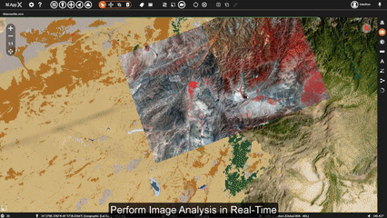
Suitable for military academies and universities who are training students for a career in the GEOINT community, M.App X is a browser-based geospatial platform for users who want to process and analyze imagery in real time using GIS and remote sensing capabilities and without the heavy cost of high-end hardware and software. M.App X fosters geospatial tradecraft creation, common usage and secure sharing of the latest intel, making up-to-date information accessible and reusable.
Centralized storage and computation eliminate the cost of maintaining multiple workstations. This enterprise solution requires only one installation. Students can use ERDAS IMAGINE via browser on any operating system, meaning individual licenses need not be purchased.
Built on decades of experience in providing image analysis capabilities, M.App X contains industry-specific tools and workflows for the GEOINT community and security organizations.


A community for educators

See M.App Enterprise in action

See M.App X in action
